Gummanayaka Fort Trek - Charming fort beckons
The sleepy quaint town of Gummanayakana palya in the valley of the bagepalli hills, is all worthy to be explored, the beautiful fort remains, the beauty of the valley and immense glorious history behind it. This fort hill has been part of the on my list for the very looks of the remains and seemed quite adventurous for what I had heard of. It is unfortunate that no steps has been taken by government to maintain the fort, every passing time, it is rendered to rubble, another trouble for the fort is the treasure hunters, who have demolished the portions of structure and dug up various places around.
History: Nayaka/Palegar Kingdom of Gummanayakana Palya (1272–1799), (Subordinate to Vijayanagara Empire until 1630) Feudatory state under the suzerainty of the Mughal Empire and Maratha Empire from 1680s. Tippu Sultan, however, embarked on a systematic policy of extermination of the Palegars. Promises made by the English commander to restore his palayapat after final victory over Tippu were not honoured by Dewan Purnaiah of the restored Wadiyars of Mysore. Narasimha was forced to go into exile once more "where he, the last Palegar to rule the ancient Palayapat of Gummanayakana Palya, died of grief." ending their era.
Difficulty Level: Easy
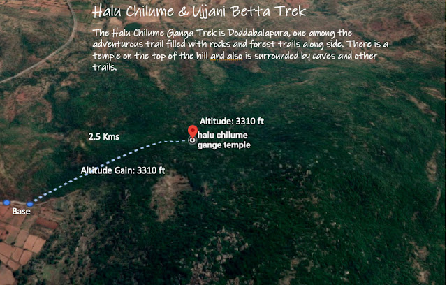
Distance: 2.5 kms (to Ujjani Betta)
Best time: Any time (Monsoon might be slippery on rocks)
DIY Trek: Yes (Children ? Yes > 8 yrs)
Trail type: Nomadic walk, stone steps and hill climb
Altitude: 2319 ft to 3,310 ft
As usual assembled at hebbal an left towards devanahalli, and then followed the highway straight to chikkaballapur and further 40 kms on hw, and deviating to Bageppalli town. The google maps show accurately so just follow the directions.
We reached the village by 7 Am in the morning, and in search of parking reached the adjoining lake and parked there and started trekking, however we did not realise we are embarking on an adventure journey as we were going around the hills, instead of straight climb. It was 2kms detour but we enjoyed the trek.
Below is the view of the fort from the side, as we trekked all around the hills, the views were astonishing and each side gave a different feel and view, made us more curious
This is the remnants of the palace structure, as per locals the structure is made to rubble by the treasure hunters. It has stood the time tests and is evident of the kings art affiliations.

vLog Video on my youtube channel:
History: Nayaka/Palegar Kingdom of Gummanayakana Palya (1272–1799), (Subordinate to Vijayanagara Empire until 1630) Feudatory state under the suzerainty of the Mughal Empire and Maratha Empire from 1680s. Tippu Sultan, however, embarked on a systematic policy of extermination of the Palegars. Promises made by the English commander to restore his palayapat after final victory over Tippu were not honoured by Dewan Purnaiah of the restored Wadiyars of Mysore. Narasimha was forced to go into exile once more "where he, the last Palegar to rule the ancient Palayapat of Gummanayakana Palya, died of grief." ending their era.
Difficulty Level: Easy
Distance: 2.5 kms (to Ujjani Betta)
Best time: Any time (Monsoon might be slippery on rocks)
DIY Trek: Yes (Children ? Yes > 8 yrs)
Trail type: Nomadic walk, stone steps and hill climb
Altitude: 2319 ft to 3,310 ft
As usual assembled at hebbal an left towards devanahalli, and then followed the highway straight to chikkaballapur and further 40 kms on hw, and deviating to Bageppalli town. The google maps show accurately so just follow the directions.
 |
| Bagepalli mountain valley |
 |
| Gummanayakana Palya Village |
 |
| Lake adjoining the fort |
 |
| Side view of Fort |
 |
| Mountain view from summit of fort hills |
 |
| Remains of the Mahal once existed |
 |
| Fort remains |
 |
| Fort Remains.. |

vLog Video on my youtube channel:
Leave critics an Comments in the comments section below:
My webpage - http://www.skmanju.com/ Instagram: https://www.instagram.com/manjukrishphoto/ Blog: ManjuKrishPhoto.Blogspot.com Write to me at skmanju@gmail.com
PS: "Information provided in the post is as is basis, please exercise caution while using the info for the trek. Author is not responsible for any discrepancies in the information"


Comments
Post a Comment
Your comments are most welcome -